
|
|
Banffshire |
|
Contents |
|
Nearby places |
|
|
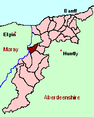
See the Maps Section below for links to a fully-detailed version of this location plan. |
"The ancient name is Bocharin; in the original signifying the bow about the cairn, or rocky hill, from its surrounding nearly three parts of the bottom of the mountain of Beneageen. The length, between the parish of Mortlich, at the west, and the parish of Bellie, at the east, is from 7 to 9 English miles; the breadth, from the parish of Botriphnie, at the south, to the highest cultivated land on the mountain, northward, is from 2 to 3 English miles; but the figure of the parish is so irregular, that these measures are to be regarded as the mean, rather than the particular length and breadth."
The Statistical Account for Scotland, 1791-1799
Monumental Inscriptions for Dundurcas are included in "Speyside Monumental Inscriptions pre-1855" published by the Scottish Genealogy Society . The significance of Dundurcas is described below under "Historical Geography".
Aberdeen And North-East Scotland FHS (ANESFHS) have published a name Index to the 1851 Census for Banffshire. Boharm (together with Grange, Keith and Botriphnie) is published as code AA216.
Kirk of Scotland
- OPRs held by the General Register Office, Scotland.
GROS Baptism Marriage Death 128A/1 1634-1783 1634-1782 1701-32 128A/2 1780-1819 1791-1819 - 128A/3 1820-54 1820-54 - - OPRs for Dundurcas (see "Historical Geography") are held as follows:
GROS Baptism Marriage Death 141/1 1698-1780 1698-1770 1718-47 Kirk Session Records
Kirk Session records generally include records of Discipline, which often include information on illegitimate births, and Accounts, which may mention persons on Poor Relief. The surviving Boharm Kirk Session records are listed on a separate webpage.
A transcript of Parish of Boharm by Rev. Francis Leslie.
There was, anciently, a parish called Dundurcas, which lay on either side of the River Spey. In 1788, it was "suppressed", and that part of its territory which lay on the east bank of the River Spey was divided between the parishes of Boharm and Rothes. The major part, which was deemed to lie in the county of Moray, was transferred to Boharm. On 15th May 1891, this area was transferred to Banffshire.
The implications of this anomaly vary for different archives, and different periods of time. Despite the clarity of the relevant facts, there is a degree of uncertainty on the part of some authorities as to which county the parish belongs to. The whole of the more recent OPRs, and the civil records of Births, Deaths and Marriages for the parish of Boharm are now catalogued under Banffshire - but with serial numbers which imply that they ought to be in Moray. If you can trace ancestors in the affected area back before 1788, then they are likely to be found in the OPRs for the parish of Rothes, Moray, which fell heir to the records for the suppressed parish of Dundurcas. People in the "ex-Dundurcas" part of Boharm appear to have continued burying their dead in the old kirkyard of Dundurcas (which now lies in the Moray parish of Rothes) until well into the 19th century.
Up to and including the 1891 Census, Boharm (including the Banffshire portions) will be found on the Census films for Moray. From 1901, it is on the Banffshire films.
Because of this complicated history, the placenames of Boharm have been split into three separate Gazetteer lists. You can view:
A list of places in Boharm (MOR) / Dundurcas,
A list of places in Boharm (BAN), and
A list of places in the parish as it was after 1891Of course, there are many overlaps between the older and newer Gazetteer lists, but in compiling these lists, we have referred only to sources which were valid when the different parts of the parish existed. So the "Boharm (BAN)" and "Boharm (MOR)" lists use only the 1887 sheets of the Ordnance Survey maps, while the "post-1891" list refers only to the 1896 edition of the OS map, and the modern Landranger and Explorer sheets.
There is a wide range of maps available for Boharm, historical and modern, on paper and online. Many ancient placenames continue in use, and will therefore appear on modern maps, but as parishes ceased to be of any significance for Local Government in Scotland in 1976, parish boundaries will be found only on historical maps.
Maps on Paper
- The best general-purpose modern printed map is the Ordnance Survey "Landranger" Series, which has a scale of 1:50000 (about one-and-a-quarter inches to a mile). Boharm will be found on "Landranger Sheet 28".
- Reproductions of late-19th century Ordnance Survey maps are published by Caledonian Maps, and are also available via Family History Societies. Boharm will be found on sheet 85.
Maps Online
- The small location plan at the head of this page is based on an 1845 map included in the Banffshire volume of the New Statistical Account of Scotland. View a fully-detailed version of this map.
- View online versions of Victorian and modern maps
Because of the complicated history of the parish (see'Historical Geography' above), the placenames of Boharm have been split into three separate Gazetteer lists. You can view:
- A list of places in Boharm (MOR) / Dundurcas
- A list of places in Boharm (BAN)
- A list of places in the parish as it was after 1891
Of course, there are many overlaps between the older and newer Gazetteer lists, but in compiling these lists, we have referred only to sources which were valid when the different parts of the parish existed. So the "Boharm (BAN)" and "Boharm (MOR)" lists use only the 1887 sheets of the Ordnance Survey maps, while the "post-1891" list refers only to the 1896 edition of the OS map, and the modern Landranger and Explorer sheets.
Under the "Poor Law Amendment Act, Scotland" (1845) responsibility for Poor Relief was taken from the Parishes of the Kirk of Scotland, and vested in new Parochial Boards, whose territories largely coincided with the old parishes. The Parochial Boards were not (as in England) grouped into Poor Law Unions, and there were few Poorhouses outside the cities and large towns.
Day-to-day administration of the Poor Law was in the hands of the Inspector of the Poor for each parish, and these Inspectors were obliged by law to maintain detailed records of applications and of relief supplied. The most valuable of these are the "Record of Applications" and the "General Register of the Poor". The "Minutes" are very variable, but on occasion can also contain information on named individuals.
The following Poor Law records have survived for the Parish of Boharm:
http://www.aberdeencity.gov.uk/education_learning/local_history/archives/loc_archiveshomepage.asp
- General Register of the Poor 1845-1929*
- Childrens' Separate Register 1853-1929
- Minutes
These are held by Aberdeen City Archives. The records are available for viewing, subject to the 100-year rule.
Items marked * are included in a name index compiled by Aberdeen And North-East Scotland FHS (ANESFHS), and held by both ANESFHS and Aberdeen City Archives.
- according to New Statistical Account:
Year 1801 1811 1821 1831 Population 1161 1190 1206 1385 - according to Ordnance Gazetteer of Scotland (1895):
Year 1831 1841 1861 1871 1891 Population 1385 1261 1412 1337 1266
If you have found any errors or omissions, or have any suggestions about this page, please use the feedback form
[Last updated: 29 August 2010, Gavin Bell]
![]()