
|
|
Banffshire |
|
Contents |
|
Nearby places |
|
|
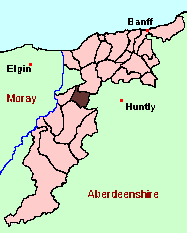
See the Maps Section below for links to a fully-detailed version of this location plan. There is also a detailed list of placenames of the parish. |
"The parish is situated about twenty-four miles west from the county town, and extends from north to south about 4½, and from east to west about 3 English miles, comprehending the whole breadth of the county, being bound by the parish of Glass, in Aberdeenshire, on the south, and on the north by part of Dundurcas, in Moray.
The greater part of the parish consistes of one beautiful strath, situated between two hills to the north and south, with the small river of Isla (which takes its rise in the west part of the parish towards Mortlach) running through the middle of it."
from: The New Statistical Account of Scotland (1841)
Aberdeen And North-East Scotland FHS (ANESFHS) have published a name Index to the 1851 Census for Banffshire. Botriphnie (together with Grange, Keith and Boharm) is published as code AA216.
ANESFHS also hold unpublished indexes and transcriptions of the 1861 Census for most Banffshire parishes (including Botriphnie).
You can view a Gazetteer list including placenames culled from the 1841, 1851 and 1861 Census.
Kirk of Scotland
- OPRs held by the General Register Office, Scotland.
GROS Baptism Marriage Death 148/1 1682-1819 1683-1819 1746-53 148/2 1820-54 1820-54 - LDS Film numbers:
Baptisms Marriages Deaths 6901969 6901970 - - Batch numbers (for FamilySearch)
Baptisms (C) Marriages (M) C111481
C111482
C111483
C111484M111481
M111482
M111484Kirk Session Records
Kirk Session records generally include records of Discipline, which often include information on illegitimate births, and Accounts, which may mention persons on Poor Relief. The surviving Botriphnie Kirk Session records are listed on a separate webpage.
There is a wide range of maps available for Botriphnie, historical and modern, on paper and online. Many ancient placenames continue in use, and will therefore appear on modern maps, but as parishes ceased to be of any significance for Local Government in Scotland in 1974, parish boundaries will be found only on historical maps.
Maps on Paper
- The best general-purpose modern printed map is the Ordnance Survey "Landranger" Series, which has a scale of 1:50000 (about one-and-a-quarter inches to a mile). Botriphnie will be found on "Landranger Sheet 29".
- Reproductions of late-19th century Ordnance Survey maps are published by Caledonian Maps, and are also available via Family History Societies. Botriphnie will be found on sheet 85.
Maps Online
- The small location plan at the head of this page is based on an 1845 map included in the Banffshire volume of the New Statistical Account of Scotland. View a fully-detailed version of this map.
- View online versions of Victorian and modern maps
You can view a Gazetteer list including placenames culled from the Ordnance Survey "Explorer" (1:25000) map, the 1896 Ordnance Survey 1" map, and the 1841, 1851 and 1861 Census.
You can view a Gazetteer list including placenames culled from the Ordnance Survey "Explorer" (1:25000) map, the 1896 Ordnance Survey 1" map, and the 1841, 1851 and 1861 Census.
Under the "Poor Law Amendment Act, Scotland" (1845) responsibility for Poor Relief was taken from the Parishes of the Kirk of Scotland, and vested in new Parochial Boards, whose territories largely coincided with the old parishes. The Parochial Boards were not (as in England) grouped into Poor Law Unions, and there were few Poorhouses outside the cities and large towns.
Day-to-day administration of the Poor Law was in the hands of the Inspector of the Poor for each parish, and these Inspectors were obliged by law to maintain detailed records of applications and of relief supplied. The most valuable of these are the "Record of Applications" and the "General Register of the Poor". The "Minutes" are very variable, but on occasion can also contain information on named individuals.
The following Poor Law records have survived for the Parish of Botriphnie:
- General Register of the Poor 1854-1929 *
- Record of Applications 1855-1929 *
- Childrens' Separate Register 1861-1893 *
These are held by Aberdeen City Archives. The records are available for viewing, subject to the 100-year rule.
Items marked * are included in a name index compiled by Aberdeen And North-East Scotland FHS (ANESFHS), and held by both ANESFHS and Aberdeen City Archives.
| Year | 1811 | 1821 | 1831 | 1841 |
| Population | 577 | 572 | 721 | 714 |
| Year | 1801 | 1811 | 1831 | 1861 | 1871 | 1881 | 1891 |
| Population | 589 | 577 | 721 | 867 | 785 | 696 | 729 |
If you have found any errors or omissions, or have any suggestions about this page, please use the feedback form
[Last updated:10 Jun 2004, Gavin Bell]
![]()