
|
|
Banffshire |
|
Contents |
|
Nearby places |
|
|
See the Maps Section below for links to a fully-detailed version of this location plan. There is also a detailed list of placenames of the parish. |
"The origin of the name is unknown. The parish is bounded by the Murray Frith on the north and north-west; by Banff on the east; by Ordiequhill on the south, and Fordyce on the west. It is of small extent, being only five English miles long, and from a mile to a mile and an half in breadth. It contains about 3000 acres, above one half of which are arable, and 400 acres are planted with wood of different kinds, but chiefly with Scotch fir. The soil of the parish is various. The agriculture is, on the whole, pretty well conducted. Though the parish is of small extent, yet there are generally from 60 to 70 acres of turnips, and 300 acres of sown grass. This parish was one of the first in the north of Scotland in which the new husbandry was attempted, and carried on with success. The late Earl of Findlater was the author of all these early improvements. The farm of Craigholes was first improved by his Lordship about 1754; and after improving this farm, to shew what could be done, he took every method of exciting his tenants to follow his example." From The Statistical Account for Scotland, 1791-1799 Volume XVI, Banffshire, Moray & Nairnshire.
Unpublished Monumental Inscriptions for Boyndie are held by Aberdeen And North-East Scotland FHS (ANESFHS). Members can request a lookup.
Aberdeen And North-East Scotland FHS (ANESFHS) have published a name Index to the 1851 Census for Banffshire. Boyndie (together with Banff and Ordiquhill) is published as code AA213.ANESFHS also hold unpublished indexes and transcriptions of the 1861 Census for most Banffshire parishes (including Boyndie).
Kirk of Scotland
- OPRs held by the General Register Office, Scotland.
GROS Baptism Marriage Death 149/1 1700-70 - - 149/2 1771-1819 1700-86 - 149/3 1820-54 1827-54 - - LDS Film numbers:
Baptisms Marriages Deaths 6901971 6901972 - - Batch numbers (for FamilySearch)
Baptisms (C) Marriages (M) C111492 M111492
A transcript of Parish of Boyndie by Rev. Alexander Milne.
There is a wide range of maps available for Boyndie, historical and modern, on paper and online. Many ancient placenames continue in use, and will therefore appear on modern maps, but as parishes ceased to be of any significance for Local Government in Scotland in 1976, parish boundaries will be found only on historical maps.
Maps on Paper
- The best general-purpose modern printed map is the Ordnance Survey "Landranger" Series, which has a scale of 1:50000 (about one-and-a-quarter inches to a mile). Boyndie will be found on "Landranger Sheet 29".
- Reproductions of late-19th century Ordnance Survey maps are published by Caledonian Maps, and are also available via Family History Societies. Boyndie will be found on sheet 96.
Maps Online
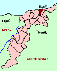
- The small location plan at the head of this page is based on an 1845 map included in the Banffshire volume of the New Statistical Account of Scotland. View a fully-detailed version of this map.
- View online versions of Victorian and modern maps
You can view a comprehensive Gazetteer list including placenames culled from the Ordnance Survey "Explorer" (1:25000) map, the 1896 Ordnance Survey 1" map, the 1841, 1851 and 1861 Census and Thomson's "Atlas of Scotland" (1832).
Under the "Poor Law Amendment Act, Scotland" (1845) responsibility for Poor Relief was taken from the Parishes of the Kirk of Scotland, and vested in new Parochial Boards, whose territories largely coincided with the old parishes. The Parochial Boards were not (as in England) grouped into Poor Law Unions, and there were few Poorhouses outside the cities and large towns.
Day-to-day administration of the Poor Law was in the hands of the Inspector of the Poor for each parish, and these Inspectors were obliged by law to maintain detailed records of applications and of relief supplied. The most valuable of these are the "Record of Applications" and the "General Register of the Poor". The "Minutes" are very variable, but on occasion can also contain information on named individuals.
The following Poor Law records have survived for the Parish of Boyndie:
- Minutes
These are held by Aberdeen City Archives. The records are available for viewing, subject to the 100-year rule.
- according to New Statistical Account:
Year 1831 1841 Population 1501 1501 - according to Ordnance Gazetteer of Scotland (1895):
Year 1801 1861 1891 Population 1122 1711 2113
If you have found any errors or omissions, or have any suggestions about this page, please use the feedback form
[Last updated: 28 Feb 2005, Gavin Bell]
![]()