
|
|
Banffshire |
|
Contents |
|
Nearby places |
|
|
See the Maps Section below for links to a fully-detailed version of this location plan. |
"The ecclesiastical parish consistes of two parts, viz. Cullen proper, or Cullen quoad civilia, and a portion of the neighbouring parish of Rathven, annexed to it quoad sacra. The former, which bears the form of a wedge, extends form north to south, in length about 1½ miles, and from east to west, in average breadth, nearly 1 mile, containing 684 imperial acres. The annexation from Rathven is about 3 miles in length, from east to west, and nearly 2 miles in breadth, from north to south. Cullen proper is bounded on the north, by the Moray Frith; on the south, by Rathven and Deskford; on the east, by Fordyce; and on the west, by Rathven."
(Contributed in May, 1842,
by the Rev. George Henderson, Minister of Cullen,
to The New Statistical Account of Scotland, Vol. XIII)More information concerning the "annexation from Rathven" will be found below, under the heading Historical Geography
Unpublished MIs for this parish are held by Aberdeen & N.E. Scotland F.H.S. and members may request lookups.
Aberdeen And North-East Scotland FHS (ANESFHS) have published a name Index to the 1851 Census for Banffshire. Cullen (together with Fordyce and Deskford) is published as code AA214. Note however, that in the 1851 Census, the western "annexed part" of Cullen quoad sacra parish appears as Registration Districts 17 and 18 of Rathven parish. (For an explanation of this, see the section Historical Geography below).
ANESFHS also hold unpublished indexes and transcriptions of the 1861 Census for most Banffshire parishes (including Cullen). The former "annexed part" of Cullen is enumerated separately as Seafield.
Kirk of Scotland
- OPRs held by the General Register Office, Scotland.
GROS Baptism Marriage Death 150/1 1668-82 1642-77 1640-48 150/2 1682-1727 1684-1727 - 150/3 1727-82 1728-81 - 150/4 1782-1819 1782-1819 - 150/5 1820-54 1820-54 1835-52 - LDS Film numbers:
Baptisms Marriages Deaths 6901973(3) 6901974(1) 990821 - Batch numbers (for FamilySearch)
Baptisms (C) Marriages (M) C111501
C111502
C111503
C111504M111501
M111502
M111503
Kirk Session Records
Kirk Session records generally include records of Discipline, which often include information on illegitimate births, and Accounts, which may mention persons on Poor Relief. The surviving Cullen Kirk Session records are listed on a separate webpage.
As part of the ongoing complication caused by the "annexed part of Rathven" (see Historical Geography for details), there is an oddity in the Civil Registrations for Cullen. In the first year of Civil Registration (1855), two Registration Districts were set up: "Cullen Burgh" (ref no 150/1) and "Cullen Landward" (ref no 150/2). In 1856, these were changed to "Cullen" (ref no 150) and "Seafield" (ref no 167). "Cullen Burgh" and then "Cullen" covered the area of "Cullen proper", while "Cullen Landward", and subsequently "Seafield", approximated to the area of the "annexed part of Rathven".
According to the writer of the New Statistical Account of Scotland (1842): "The parish of Cullen originally formed part of the parish of Fordyce, from which it was disjoined at a very remote period." This splitting off seems to have occurred well before any of the surviving records of the parishes concerned, and can be ignored for practical purposes.
However, the annexation of part of Rathven parish to Cullen quoad sacra (that is, "for church purposes"), while it also seems to have occurred in the distant past, definitely does have implications for genealogical research. Details will be found in the article on Cullen quoad sacra
There is a wide range of maps available for Cullen, historical and modern, on paper and online. Many ancient placenames continue in use, and will therefore appear on modern maps, but as parishes ceased to be of any significance for Local Government in Scotland in 1974, parish boundaries will be found only on historical maps.
Maps on Paper
- The best general-purpose modern printed map is the Ordnance Survey "Landranger" Series, which has a scale of 1:50000 (about one-and-a-quarter inches to a mile). Cullen will be found on "Landranger Sheet 29".
- Reproductions of late-19th century Ordnance Survey maps are published by Caledonian Maps, and are also available via Family History Societies. Cullen will be found on sheet 96.
Maps Online
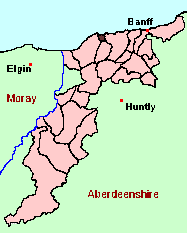
- The small location plan at the head of this page is based on an 1845 map included in the Banffshire volume of the New Statistical Account of Scotland. View a fully-detailed version of this map.
- View online versions of Victorian and modern maps
You can view a comprehensive Gazetteer list including placenames culled from the Ordnance Survey "Explorer" (1:25000) map, the 1896 Ordnance Survey 1" map, the 1841, 1851 and 1861 Census and Thomson's "Atlas of Scotland" (1832).
According to the author of the article in the New Statistical Account, writing in 1842:
"The names more peculiar to the parish, and of oldest standing are, Anderson, Coul, Davidson, Finlay, Forsyth, Gardiner, Hay, Ogilvie, Runcie, Simpson, Strahan, and Wright. In consequence of the frequent identity of Christian and surnames among the fishing population, caused by intermarriages, certain extra names are used to distinguish individuals. Thus, there are several heads of families of the respective names of Alexander Addison, James Addison, and William Addison, who are thus distinguished, viz. Alexander Addison, Saunders; Alexander Addison, Kitty's Saunie; Alexander Addison, Drodlie; James Addison, Kitty's Jamesy; James Addison, Tatie Fiddler; James Addison, Bubblie; William Addison, Sheepie; William Addison, Boatierow; William Addison, Calkinapin; William Addison, May's Wilsie. "
The author of the article in the New Statistical Account, writing in 1842, adds a detailed breakdown of numbers of each occupation in the parish.
Under the "Poor Law Amendment Act, Scotland" (1845) responsibility for Poor Relief was taken from the Parishes of the Kirk of Scotland, and vested in new Parochial Boards, whose territories largely coincided with the old parishes. The Parochial Boards were not (as in England) grouped into Poor Law Unions, and there were few Poorhouses outside the cities and large towns.
Day-to-day administration of the Poor Law was in the hands of the Inspector of the Poor for each parish, and these Inspectors were obliged by law to maintain detailed records of applications and of relief supplied. The most valuable of these are the "Record of Applications" and the "General Register of the Poor". The "Minutes" are very variable, but on occasion can also contain information on named individuals.
The following Poor Law records have survived for the Parish of Cullen:
- Minutes
These are held by Aberdeen City Archives. The records are available for viewing, subject to the 100-year rule.
- according to New Statistical Account:
Year 1791 1801 1811 1821 1831 1841 Population 1214 1076 1070 1452 1593 1564 These figures refer to "Cullen proper", that is, excluding the "annexed part of Rathven". The writer of the Statistical Account of Scotland provided the following additional information for 1791:
Cullen, proper: 1214 Annexed part of Rathven: 505 The writer of the New Statistical Account of Scotland similarly noted the following additional figures for 1841:
Cullen proper Town of Cullen 712 Seatown of Cullen 710 Rural district 142 Annexed part of Rathven Village of Portknockie 725 Rural district 333
- according to Ordnance Gazetteer of Scotland (1895):
Year 1801 1831 1861 1871 1881 1891 Population 1076 1593 1975 2215 2236 2319
If you have found any errors or omissions, or have any suggestions about this page, please use the feedback form.
[Last updated: 12 Dec 2004, Gavin Bell]
![]()