
|
|
Banffshire |
|
Contents |
|
Nearby places |
|
|
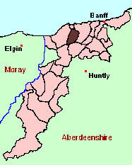
See the Maps Section below for links to a fully-detailed version of this location plan. |
"Extent and Boundaries - The length of this parish is rather more than 5 miles, and its breadth somewhat above 3. It is bounded, on the south, by Grange; on the west, by Rathven; on the north, by Cullen, and that part of Rathven annexed quoad sacra to Cullen; and on the east, by Fordyce.
Topographical Appearances - The form of the parish is nearly that of a parallelogram. It is intersected by a small stream called the burn of Deskford, which rises in the adjoining parish of Grange, and is increased in its course through Deskford by many streamlets from the rising grounds on each side of it, running down small glens or ravines, beautifully fringed with natural wood on each side of them, as is the burn."
from: The New Statistical Account of Scotland (1836)
Aberdeen And North-East Scotland FHS (ANESFHS) hold some unpublished MIs for Deskford. Members may request lookups
These are included in the Online Index to the MIs
Aberdeen And North-East Scotland FHS (ANESFHS) have published a name Index to the 1851 Census for Banffshire. Deskford (together with Fordyce and Cullen) is published as code AA214.ANESFHS also hold unpublished indexes and transcriptions of the 1861 Census for most Banffshire parishes (including Deskford).
Kirk of Scotland
- OPRs held by the General Register Office, Scotland.
GROS Baptism Marriage Death 151/1 1660-1819 - - 151/2 - 1659-1819 - 151/3 1820-55 1819-55 - - LDS Film numbers:
Baptisms Marriages Deaths 6901975(2) 6901976(1) - - Batch numbers (for FamilySearch)
Baptisms (C) Marriages (M) C111511
C111512
C111513M111511
M111512
M111514Kirk Session Records
Kirk Session records generally include records of Discipline, which often include information on illegitimate births, and Accounts, which may mention persons on Poor Relief. The surviving Deskford Kirk Session records are listed on a separate webpage.
There is a wide range of maps available for Deskford, historical and modern, on paper and online. Many ancient placenames continue in use, and will therefore appear on modern maps, but as parishes ceased to be of any significance for Local Government in Scotland in 1974, parish boundaries will be found only on historical maps.
Maps on Paper
- The best general-purpose modern printed map is the Ordnance Survey "Landranger" Series, which has a scale of 1:50000 (about one-and-a-quarter inches to a mile). Deskford will be found on "Landranger Sheet 29".
- Reproductions of late-19th century Ordnance Survey maps are published by Caledonian Maps, and are also available via Family History Societies. Deskford will be found on sheets 86 and 96.
Maps Online
- The small location plan at the head of this page is based on an 1845 map included in the Banffshire volume of the New Statistical Account of Scotland. View a fully-detailed version of this map.
- View online versions of Victorian and modern maps
You can view a comprehensive Gazetteer list including placenames culled from the Ordnance Survey "Explorer" (1:25000) map, the 1896 Ordnance Survey 1" map, the 1841, 1851 and 1861 Census and Thomson's "Atlas of Scotland" (1832).
Under the "Poor Law Amendment Act, Scotland" (1845) responsibility for Poor Relief was taken from the Parishes of the Kirk of Scotland, and vested in new Parochial Boards, whose territories largely coincided with the old parishes. The Parochial Boards were not (as in England) grouped into Poor Law Unions, and there were few Poorhouses outside the cities and large towns.
Day-to-day administration of the Poor Law was in the hands of the Inspector of the Poor for each parish, and these Inspectors were obliged by law to maintain detailed records of applications and of relief supplied. The most valuable of these are the "Record of Applications" and the "General Register of the Poor". The "Minutes" are very variable, but on occasion can also contain information on named individuals.
The following Poor Law records have survived for the Parish of Deskford:
- Minutes
These are held by Aberdeen City Archives. The records are available for viewing, subject to the 100-year rule.
Items marked * are included in a name index compiled by Aberdeen And North-East Scotland FHS (ANESFHS), and held by both ANESFHS and Aberdeen City Archives.
- according to Statistical Account and New Statistical Account:
Year 1790 1811 1821 1831 Population 752 634 693 828 - according to Ordnance Gazetteer of Scotland (1895):
Year 1801 1831 1861 1871 1881 1891 Population 610 828 1031 972 849 745
If you have found any errors or omissions, or have any suggestions about this page, please use the feedback form
[Last updated: 12 Dec 2004, Gavin Bell]
![]()