
|
|
Banffshire |
|
Contents |
|
Nearby places |
|
|
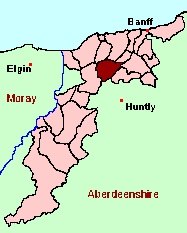
See the Maps Section below for links to a fully-detailed version of this location plan. |
"The parish is six miles long by five broad. It is bounded on the east, by the Knock, a hill, about 1600 feet above the level of the sea. This hill is cultivated a good way up, on all sides. The greater part of its surface is deep peat, and heather. On the top the moss is from eight to ten feet deep. In the dry year 1826, the surface was burnt round and round, having caught fire, either by accident or design, nobody knows which. There is a very extensive view from it both of sea and land - Grange is bounded on the east, west, and south, by the parishes of Marnock, Rothiemay, Cairney, and Keith; on the north, by that of Deskford and part of Fordyce. On the northern part there are two hills, the Lurghill and the hill of Altmore, now called Aulmore, which signifies the great burn. In the centre there is the Sillyearn, on which there is an extensive plantation, young and thriving. In the southern part there are the Mickle and little Balloch, the lower parts of which are now covered with wood. Towards the top there could be no hope of a tree, as it is dry, rough and rocky. On the Mickle Balloch, there are several graves of some unhappy suicides, marked by a cairn, not sacred to their memory, but to tell of their unchristian burial and untimely end. Here is the Gallow-hill, too, of which tradition speaks with fear and trembling. On this memorable mount the criminals of the district met their ignominious fate. The abbots, as well as the feudal barons of those days, had the power to condemn without appeal, and, it is likely, to execute without justice." From The New Statistical Account for Scotland.
Aberdeen And North-East Scotland FHS (ANESFHS) have published a name Index to the 1851 Census for Banffshire. Grange (together with Keith, Bohrm and Botriphnie) is published as code AA216.ANESFHS also hold unpublished indexes and transcriptions of the 1861 Census for most Banffshire parishes (including Grange).
Kirk of Scotland
- OPRs held by the General Register Office, Scotland.
GROS Baptism Marriage Death 156/1 1684-1754 - - 156/2 1754-1819 - - 156/3 - 1683-1819 1783-91 156/4 1820-54 1820-54 - - LDS Film numbers:
Baptisms Marriages Deaths 6902569 6902570 990996 Kirk Session Records
Kirk Session records generally include records of Discipline, which often include information on illegitimate births, and Accounts, which may mention persons on Poor Relief. The surviving Grange Kirk Session records are listed on a separate webpage.
A transcript of Parish of Grange by Rev. William Duff.
There is a wide range of maps available for Grange, historical and modern, on paper and online. Many ancient placenames continue in use, and will therefore appear on modern maps, but as parishes ceased to be of any significance for Local Government in Scotland in 1976, parish boundaries will be found only on historical maps.
Maps on Paper
- The best general-purpose modern printed map is the Ordnance Survey "Landranger" Series, which has a scale of 1:50000 (about one-and-a-quarter inches to a mile). Grange will be found on "Landranger Sheet 29".
- Reproductions of late-19th century Ordnance Survey maps are published by Caledonian Maps, and are also available via Family History Societies. Grange will be found on sheets 86.
Maps Online
- The small location plan at the head of this page is based on an 1845 map included in the Banffshire volume of the New Statistical Account of Scotland. View a fully-detailed version of this map.
- View online versions of Victorian and modern maps
You can view a comprehensive Gazetteer list for Grange including placenames culled from the Ordnance Survey "Explorer" (1:25000) map, the 1896 Ordnance Survey 1" map, the 1841, 1851 and 1861 Census and Thomson's "Atlas of Scotland" (1832).
You can view a comprehensive Gazetteer list for Grange including placenames culled from the Ordnance Survey "Explorer" (1:25000) map, the 1896 Ordnance Survey 1" map, the 1841, 1851 and 1861 Census and Thomson's "Atlas of Scotland" (1832).
Under the "Poor Law Amendment Act, Scotland" (1845) responsibility for Poor Relief was taken from the Parishes of the Kirk of Scotland, and vested in new Parochial Boards, whose territories largely coincided with the old parishes. The Parochial Boards were not (as in England) grouped into Poor Law Unions, and there were few Poorhouses outside the cities and large towns.
Day-to-day administration of the Poor Law was in the hands of the Inspector of the Poor for each parish, and these Inspectors were obliged by law to maintain detailed records of applications and of relief supplied. The most valuable of these are the "Record of Applications" and the "General Register of the Poor". The "Minutes" are very variable, but on occasion can also contain information on named individuals.
The following Poor Law records have survived for the Parish of Grange:
- General Register of the Poor 1845-1929 *
- Record of Applications 1855-1929 *
- Childrens' Separate Register 1914-1928 *
- Minutes
These are held by Aberdeen City Archives. The records are available for viewing, subject to the 100-year rule.
Items marked * are included in a name index compiled by Aberdeen And North-East Scotland FHS (ANESFHS), and held by both ANESFHS and Aberdeen City Archives.
- according to New Statistical Account:
Year 1811 1821 1831 1841 Population 1510 1482 1492 1661 - according to Ordnance Gazetteer of Scotland (1895):
Year 1801 1831 1861 1891 Population 1529 1492 1909 1685
If you have found any errors or omissions, or have any suggestions about this page, please use the feedback form
[Last updated: 30 Jan 2006, Gavin Bell]
![]()