
|
|
Banffshire |
|
Contents |
|
Nearby places |
|
|
See the Maps Section below for links to a fully-detailed version of this location plan. |
Note: There are 4 other parishes in Scotland called 'Kirkmichael':
Kirkmichael, Ayrshire
Kirkmichael, Dumfriesshire
Kirkmichael, Perthshire
Kirkmichael or Resolis, Ross and Cromarty"The parish is upwards of 30 miles in length from north to south along the banks of the Avon, a tributary branch of the Spey; and its average breadth is from 3 to 4 miles. Only about 18 miles of its length is inhabited. the other 12 or 15 stretch into the Grampian hills, and are uninhabited. Of this territorial extent, about 9 miles of the inhabited part, and all of the uninhabited portion, lie in the quoad sacra parish of Tomintoul. The main range of the Grampian mountains on the south, and branches of that range running from south to north on the east and west form its boundaries, and encircle it, except on the north, where it joins the parish of Inveravon in a narrow neck at the outlet of the Avon."
(Contributed in April, 1842,
by the Rev. Charles Macpherson, Minister of Tomintoul,
to The New Statistical Account of Scotland, Vol. XIII)
Aberdeen And North-East Scotland FHS (ANESFHS) have published a name Index to the 1851 Census for Banffshire. Kirkmichael (together with Tomintoul, which was enumerated separately form the rest of the parish, and Inveravon) is published as code AA218.ANESFHS also hold unpublished indexes and transcriptions of the 1861 Census for most Banffshire parishes (including Kirkmichael).
Kirk of Scotland
- OPRs held by the General Register Office, Scotland.
GROS Baptism Marriage Death 160/1 1725-1819 1726-1819 - 160/2 Kirkmichael 1820-54 Kirkmichael 1820-54 - 160/2 Tomintoul 1827-46 Tomintoul 1828-43 - - LDS Film numbers:
Baptisms Marriages Deaths 6902577 6902578 - - Batch numbers (for FamilySearch)
Baptisms (C) Marriages (M) C111602
C111604M111602
M111604Kirk Session Records
The earliest Kirk Session records held by the national Archives of Scotland only date from 1897.
There is a wide range of maps available for Kirkmichael, historical and modern, on paper and online. Many ancient placenames continue in use, and will therefore appear on modern maps, but as parishes ceased to be of any significance for Local Government in Scotland in 1974, parish boundaries will be found only on historical maps.
Maps on Paper
- The best general-purpose modern printed map is the Ordnance Survey "Landranger" Series, which has a scale of 1:50000 (about one-and-a-quarter inches to a mile). Kirkmichael will be found on "Landranger Sheets 36 and 37".
- Reproductions of late-19th century Ordnance Survey maps are published by Caledonian Maps, and are also available via Family History Societies. Kirkmichael will be found on sheet 75.
Maps Online
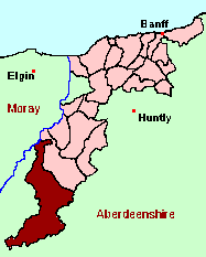
- The small location plan at the head of this page is based on an 1845 map included in the Banffshire volume of the New Statistical Account of Scotland. View a fully-detailed version of this map.
- View online versions of Victorian and modern maps
Achlichnie, Alltachbeg, Alltnaha, Altnaglander, Ardgieth, Auchbreck, Auchnahyle, Auchnarrow, Auchriachan, Badnafrave, Ballcorach, Ballenlish, Balnalon, Balneden, Balranaich, Birchfield, Blairnamarrow, Bridge of Avon, Bridge of Brown, Builg, Bynack, Campdalmore, Casfuar, Clashnoir, Conglass, Croughly, Cults, Dalestie, Delachule, Delavorar, Dell, Delnabo, Dulack, Eag, Ellick, Etchachan, Faindouran, Fergie, Findron, Fodderletter, Gaulrig, Glenconglass, Glenmullie, Inchnacape, Inchrory, Inverchor, Inverlochy, Inverourie, Kennels, Kinardochy, Kirkmichael, Knock, Knoc-Lochy Well, Kylnadrochit, Lagganauld, Lagganvoulin, Leachd, Lecht, Lochy, Lynachork, Lynavoir, Lyne, Milton(2), Ruthven, St.Bridget, Strathavon, Stronachavie, Tomachlaggan, Tombreck, Tomintoul, Tomlay, Torbain, Torrans, Urlamore
Under the "Poor Law Amendment Act, Scotland" (1845) responsibility for Poor Relief was taken from the Parishes of the Kirk of Scotland, and vested in new Parochial Boards, whose territories largely coincided with the old parishes. The Parochial Boards were not (as in England) grouped into Poor Law Unions, and there were few Poorhouses outside the cities and large towns.
Day-to-day administration of the Poor Law was in the hands of the Inspector of the Poor for each parish, and these Inspectors were obliged by law to maintain detailed records of applications and of relief supplied. The most valuable of these are the "Record of Applications" and the "General Register of the Poor". The "Minutes" are very variable, but on occasion can also contain information on named individuals.
The following Poor Law records have survived for the Parish of Kirkmichael:
- *General Register of the Poor 1879-1920
- Minutes
These are held by Aberdeen City Archives. The records are available for viewing, subject to the 100-year rule.
Items marked * are included in a name index compiled by Aberdeen And North-East Scotland FHS (ANESFHS), and held by both ANESFHS and Aberdeen City Archives.
- according to New Statistical Account:
Year 1755 1792 1811 1821 1831 1839 Population 1288 1276 1386 1570 1741 1722 - according to Ordnance Gazetteer of Scotland (1895):
Year 1801 1831 1861 1871 1881 1891 Population 1332 1741 1511 1276 1073 1043
If you have found any errors or omissions, or have any suggestions about this page, please use the feedback form
[Last updated: 4 November 2004, Gavin Bell]
![]()