
|
|
Banffshire |
|
Contents |
|
Nearby places |
|
|
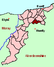
See the Maps Section below for links to a fully-detailed version of this location plan. |
"The parish of Rothiemay is bounded, on the E. and N. E. by the parish of Marnoch; on the S. and S. E. by Inverkeithnie, Forgue, and Huntly; on the W. and S. W. by Cairny; on the N. and N. W. by Grange. Its greatest length is from 7 to 8 miles, its greatest breadth from 5 to 6. The northern part of this parish is inferior to the rest, both in fertility and beauty. Beside some hilly ground, and some plantations of fir, it consists of a large plain, containing partly arable, partly pasture-ground, and an extensive moss that supplies with fuel, not only the parishioners, but, in a great measure, the town of Huntly, which is distant about 6 miles. From this plain is a gentle declivity of more than half a mile, on the W. and S. W. to the Isla, and, on the S. to the Devoran; a river adorned with plantations and natural woods on its banks, and abounding with common trout, eel, and salmon. About a mile below its confluence with the Isla, the Devoran, running eastward, divides the parish into two parts, of which the northern follows the course of the river more than two miles, the southern near two miles farther. At this point, where the Devoran begins to divide the parish, and on its northern bank, are the Milltown, a small village containing about an hundred souls; the house of Rothiemay; the church and manse; and a happy mixture of well-inclosed fields and woods; which, with woods and corn-fields on the opposite side of the river, rising, by a gradual ascent, to a great height, form a beautiful rural scenery, equalled by few, and perhaps excelled by none, of equal extent, in the kingdom. ." From The Statistical Account for Scotland, 1791-1799 Volume XVI, Banffshire, Moray & Nairnshire.
Aberdeen And North-East Scotland FHS (ANESFHS) have published a name Index to the 1851 Census for Banffshire. Rothiemay (together with Marnoch, Forglen and Inverkeithny) is published as code AA211.ANESFHS also hold unpublished indexes and transcriptions of the 1861 Census for most Banffshire parishes (including Rothiemay).
Kirk of Scotland
- OPR Dates: Baptisms 1658-1710, 1748-1854, Marriages 1601-1661, 1677-1736, 1751-1854, Burials 1654-1799.
- LDS Film No. 991195
Kirk Session Records
Kirk Session records generally include records of Discipline, which often include information on illegitimate births, and Accounts, which may mention persons on Poor Relief. The surviving Rothiemay Kirk Session records are listed on a separate webpage.
A transcript of Parish of Rothiemay by Rev. James Simmie.
There is a wide range of maps available for Rothiemay, historical and modern, on paper and online. Many ancient placenames continue in use, and will therefore appear on modern maps, but as parishes ceased to be of any significance for Local Government in Scotland in 1976, parish boundaries will be found only on historical maps.
Maps on Paper
- The best general-purpose modern printed map is the Ordnance Survey "Landranger" Series, which has a scale of 1:50000 (about one-and-a-quarter inches to a mile). Rothiemay will be found on "Landranger Sheet 29".
- Reproductions of late-19th century Ordnance Survey maps are published by Caledonian Maps, and are also available via Family History Societies. Rothiemay will be found on sheets 86.
Maps Online
- The small location plan at the head of this page is based on an 1845 map included in the Banffshire volume of the New Statistical Account of Scotland. View a fully-detailed version of this map.
- View online versions of Victorian and modern maps
You can view a comprehensive Gazetteer list for Rothiemay including placenames culled from the Ordnance Survey "Explorer" (1:25000) map, the 1896 Ordnance Survey 1" map, the 1841, 1851 and 1861 Census and Thomson's "Atlas of Scotland" (1832).
You can view a comprehensive Gazetteer list for Rothiemay including placenames culled from the Ordnance Survey "Explorer" (1:25000) map, the 1896 Ordnance Survey 1" map, the 1841, 1851 and 1861 Census and Thomson's "Atlas of Scotland" (1832).
Under the "Poor Law Amendment Act, Scotland" (1845) responsibility for Poor Relief was taken from the Parishes of the Kirk of Scotland, and vested in new Parochial Boards, whose territories largely coincided with the old parishes. The Parochial Boards were not (as in England) grouped into Poor Law Unions, and there were few Poorhouses outside the cities and large towns.
Day-to-day administration of the Poor Law was in the hands of the Inspector of the Poor for each parish, and these Inspectors were obliged by law to maintain detailed records of applications and of relief supplied. The most valuable of these are the "Record of Applications" and the "General Register of the Poor". The "Minutes" are very variable, but on occasion can also contain information on named individuals.
The following Poor Law records have survived for the Parish of Rothiemay:
- General Register of the Poor 1845-1930 *
- Record of Applications 1855-1930 *
- Childrens' Separate Register 1855-1899 *
These are held by Aberdeen City Archives. The records are available for viewing, subject to the 100-year rule.
Items marked * are included in a name index compiled by Aberdeen And North-East Scotland FHS (ANESFHS), and held by both ANESFHS and Aberdeen City Archives.
- according to New Statistical Account:
Year 1801 1811 1821 1831 1841 Population 1061 1067 1154 1228 1227 - according to Ordnance Gazetteer of Scotland (1895):
Year 1801 1831 1861 1871 1881 1891 Population 1061 1228 1414 1370 1363 1291
If you have found any errors or omissions, or have any suggestions about this page, please use the feedback form
[Last updated: 30 Jan 2006, Gavin Bell]
![]()