
|
|
Banffshire |
|
Contents |
|
Nearby places |
|
"The Parish is five and a half miles in extreme length, and its greatest breadth is three and a half miles; it contains 7878 acres, and is bounded on the south by the river Ugie, and on the east by the German Ocean. The shore is marked only by one point of any note, called Scotstown Craig, the beach being generally low and sandy; but at a small distance from the coast, a line of hills runs along, covered with a thick bed of drifted sand, overgrown with grass, and which divides the shore from the interior land and forms a natural and efficient rampart against the drifting of the sands into the country by the violence of the east wind. ... The only high land approximating to the character of an eminence is the Castle hill, in the vicinity of Inverugie Castle. The climate, on account of the exposure to the sea, is cold, and the impervious character of the subsoil renders it damp; yet it is not found to be unhealthy. There are some good springs in the lower lands which yield a constant supply of water; but in the upper part a drought sometimes occurs. especially in the hot summer months."
Lewis's Topographical Dictionary of Scotland (1846)
Draft Monumental Inscriptions for St Fergus are held by Aberdeen And North-East Scotland FHS (ANESFHS) Members may request a lookup.
Kirk of Scotland
- OPRs held by the General Register Office, Scotland.
GROS Baptism Marriage Death 166/1 1688-1768 1783-1819 1783-1819 166/2 1769-1819 - 166/3 1688-1819 - 166/4 1819-54 1820-54 1820-54 - LDS Film numbers:
Baptisms Marriages Deaths 6902589(2) 6902590 - - Batch numbers (for FamilySearch)
Baptisms (C) Marriages (M) C111661
C111662
C111663
C111664M111661
M111662
M111664Kirk Session Records
Kirk Session records generally include records of Discipline, which often include information on illegitimate births, and Accounts, which may mention persons on Poor Relief. The surviving St Fergus Kirk Session records are listed on a separate webpage.
"A strong natural rampart of closely connected clay hills, elevated by the accumulation of drift sand, and thickly covered with bent grass, divides the shore from the land ... Along this line, but of various breadth, runs a plain of the finest downs or links perhaps anywhere in Scotland, affording excellent pasture for sheep and young cattle, and capital ground for the golf-player, though perhaps rather too level for the lovers of a hazardous game. The lower part of the parish, to the extent of a mile from the shore, presents a flat appearance, from whence it gradually rises in elevation towards the western extremity, with many beautiful undulations."
Rev. James Anderson, writing in the "New Statistical Account" in 1840
"This parish was formerly named Langley, and originally Inverugie. It assumed its present designation in 1616; ... it belongs to the County of Banff, to which it was annexed at a very early period through the influence of the Cheynes, the ancient proprietors, who, being the hereditary Sheriffs of Banff, were naturally very desirous to have their own domains placed under their own jurisdiction." - Rev. James Anderson, writing in the "New Statistical Account" in 1840.
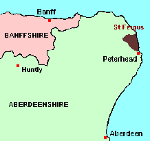
Being a "detached part" of lying some 20 miles away from the Banffshire "mainland", St Fergus represented one of the largest of the anomalies which were corrected on 1st May, 1891, but it was a quite straightforward one. Up until that date, the entire parish belonged to Banffshire; after that date, the entire parish belonged to Aberdeenshire. But (perhaps because it was such a large anomaly) different records for St Fergus are liable to appear under either Aberdeenshire or Banffshire.
You can view here a comprehensive Gazetteer list for St Fergus.
There is a wide range of maps available for St Fergus, historical and modern, on paper and online. Many ancient placenames continue in use, and will therefore appear on modern maps, but as parishes ceased to be of any significance for Local Government in Scotland in 1974, parish boundaries will be found only on historical maps.
Maps on Paper
- The best general-purpose modern printed map is the Ordnance Survey "Landranger" Series, which has a scale of 1:50000 (about one-and-a-quarter inches to a mile). St Fergus will be found on "Landranger Sheet 30".
- Reproductions of late-19th century Ordnance Survey maps are published by Caledonian Maps, and are also available via Family History Societies. St Fergus will be found on sheet 87.
Maps Online
- View online versions of Victorian and modern maps
Until 1st May, 1891,St Fergus belonged to Banffshire; thereafter it belonged to Aberdeenshire. You can view a comprehensive Gazetteer list for St Fergus including placenames culled from the Ordnance Survey "Explorer" (1:25000) map, the 1876 Ordnance Survey 1" map, the 1841, 1851, 1861 and 1881 Census and Thomson's "Atlas of Scotland" (1832).
Under the "Poor Law Amendment Act, Scotland" (1845) responsibility for Poor Relief was taken from the Parishes of the Kirk of Scotland, and vested in new Parochial Boards, whose territories largely coincided with the old parishes. The Parochial Boards were not (as in England) grouped into Poor Law Unions, and there were few Poorhouses outside the cities and large towns.
Day-to-day administration of the Poor Law was in the hands of the Inspector of the Poor for each parish, and these Inspectors were obliged by law to maintain detailed records of applications and of relief supplied. The most valuable of these are the "Record of Applications" and the "General Register of the Poor". The "Minutes" are very variable, but on occasion can also contain information on named individuals.
The following Poor Law records have survived for the Parish of St Fergus:
- General Register of the Poor 1865-1927*
- Minutes
These are held by Aberdeen City Archives. The records are available for viewing, subject to the 100-year rule.
Items marked * are included in a name index compiled by Aberdeen And North-East Scotland FHS (ANESFHS), and held by both ANESFHS and Aberdeen City Archives.
- according to New Statistical Account:
Year 1755 1775 1801 1811 1821 1831 Population 1271 1254 1270 1378 1356 1334 - according to Ordnance Gazetteer of Scotland (1895):
Year 1801 1831 1861 1871 1881 1891 Population 1270 1334 1608 1633 1527 1318
If you have found any errors or omissions, or have any suggestions about this page, please use the feedback form
[Last updated: 29 August 2010Gavin Bell]
![]()